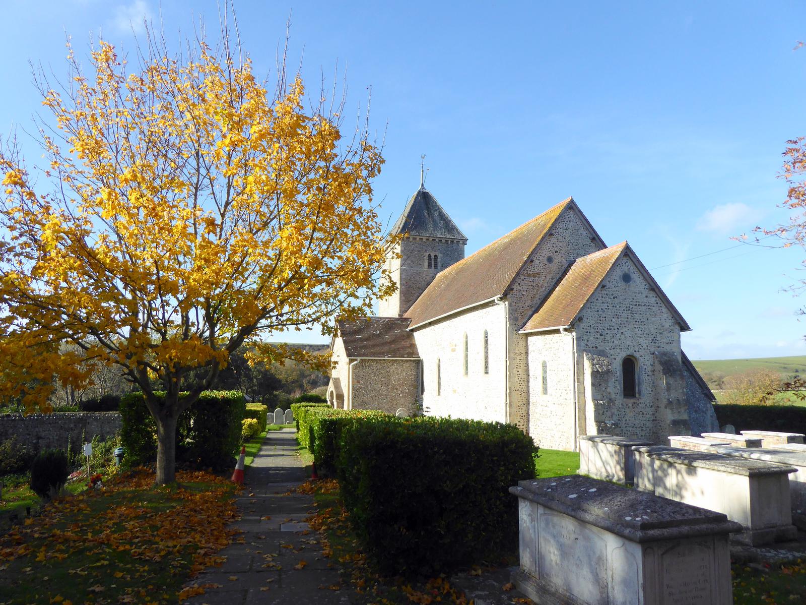
Bishopstone and Back: A Circular Walk to Sussex's Saxon Church
A half-day circular walk of about 4.5 miles from Seaford station over the Downs to Bishopstone and St Andrew's, one of the oldest churches in Sussex, with its Saxon porch and mysterious EADRIC sundial, returning past Rookery Hill, Bishopstone's Art Deco station, the ruins of Tide Mills and the seafront. Includes stiles, bail-out points and what to look for inside the church.
Turn west from Seaford and within an hour's stroll you reach Bishopstone: a hamlet of flint cottages tucked into a fold of the Downs around St Andrew's, one of the oldest churches in Sussex. This half-day circular takes you out over the fields, into the church, and home past the ruins of Tide Mills and along the shingle.
Before You Set Off
- Start and finish: Seaford station.
- Distance and time: about 7km. Allow two and a half to three hours with time in the church and at Tide Mills.
- Map: OS Explorer OL25 (Eastbourne and Beachy Head).
- Terrain: field paths that can be muddy in winter, one modest climb on the way out, then flat all the way home. There are two stiles on the field path south of the church; a stile-free alternative is given below.
- Bail-out points: Bishopstone station, on the Seaford branch, is about halfway round, with trains back to Seaford. Buses along the A259 between Brighton and Eastbourne also stop near Bishopstone and Tide Mills.
- Refreshments: none in Bishopstone itself. The Galley cafe at the Seaford and Newhaven Sailing Club and the kiosk on The Salts are on the return leg.
Out Through East Blatchington
Head north-west from the station through East Blatchington, a separate village until Seaford swallowed it, to St Peter's church. From here pick up the public footpath and the bridleway known as Silver Lane, which run west over the shoulder of the Downs to Bishopstone.
As you crest the rise, look left. The flat-topped hill south of the village is Rookery Hill, one of the most important archaeological sites in the county. Martin Bell excavated there between 1967 and 1975 and found traces of Neolithic, Bronze Age, Iron Age, Roman and early Saxon occupation, including an Anglo-Saxon cemetery whose full publication is still being prepared with Brighton and Hove Museums. The flat valley between Rookery Hill and Hawth Hill was once a tidal creek.
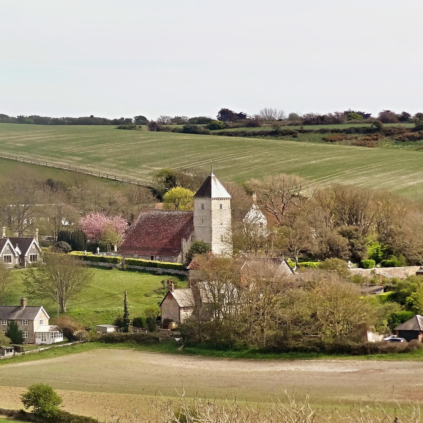
The Bishop's Village
The name means "the bishop's dwelling place", and Domesday Book (1086) records the manor as held by the Bishop of Chichester, with 52 households. Between 2002 and 2005 Dr Gabor Thomas of the University of Reading excavated the later Saxon settlement in the valley below Rookery Hill, beside the church, and found timber halls and a cellared building. His 2010 report made Bishopstone a textbook example of the "Middle Saxon shift", when communities moved off the hilltops into the valleys where most English villages still stand.
Inside St Andrew's
St Andrew's has long been claimed as the oldest church in Sussex. Its nave walls, less than 2ft 6in thick with long-and-short quoins at the corners, are pre-Conquest. Older accounts say 8th or 9th century; recent scholarship prefers nearer 1000. What to look for:
- The south porch. It began as a Saxon *porticus*, a side chapel, and was turned into the entrance porch in the 12th century, when the outer arch was added. A 14th-century niche in its east wall marks where the porticus altar once stood.
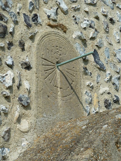
- The EADRIC sundial. Above the porch doorway is a Saxon canonical sundial, its lines marking the hours of prayer and ending in small crosses. It is carved with the name EADRIC. Who he was is unknown; suggestions range from a 680s King of Kent to a later local thegn. The dial has been reset in the wall, so it cannot date the building around it.
- The Norman tower. The four-stage tower stands slightly apart from the nave because the thin Saxon west wall could not carry its weight. Look up for the circular window and the grotesque carved heads beneath the pyramid spire, rebuilt in that form in 1885.
- Inside: a plain 12th-century font on four corner shafts, a late 12th-century chancel arch with stiff-leaf capitals, and a 12th-century carved coffin lid in the tower, rediscovered in 1849 after years of use as a chimney piece. Look too for the memorial to the poet James Hurdis (1763 to 1801), who was born in the village and became Oxford Professor of Poetry.
The church is usually open during the day for visitors and private prayer, but hours depend on volunteers, so check the A Church Near You (opens in a new tab) page before you go. The churchyard is always open.
Down to the Sea
Leave by the road opposite the church. Where it bends right, go straight on into the field and take the clear right-hand path. Cross the next field on either side of the hedge; the paths meet again at a stile, which brings you out on the A259. Cross with great care, as traffic is fast. To avoid both stiles, follow the lane on the right instead to the A259, turn left on the pavement and rejoin the route just before the station.
Go under the railway bridge. Bishopstone station, a red-brick Art Deco building of 1938 with a Second World War pillbox added, is on your left and makes a good bail-out.
Beyond lie the ruins of Tide Mills. The tide mill was built in 1761 and ground corn until 1883. The last residents of the village around it left in the 1930s. Our full Tide Mills guide (opens in a new tab) tells the story.
Home Along the Shingle
Turn left along the seafront on the concrete path signed for the Vanguard Way and Sussex Ouse Valley Way, with the beach on your right. When the concrete runs out, cross the main road and go down the slope into The Salts, home of the cricket below sea level (opens in a new tab). Cross the grass, keep right of the car park onto Richmond Road, then turn left into Dane Road for Seaford station.
Sources
- Sussex Parish Churches: Bishopstone, St Andrew (opens in a new tab)
- Wikipedia: Bishopstone, East Sussex (opens in a new tab)
- A Church Near You: St Andrew's, Bishopstone (opens in a new tab)
- Saturday Walkers Club: Seaford Circular via Alfriston and Bishopstone (SWC 314) (opens in a new tab)
- Saturday Walkers Club: Bishopstone Circular (opens in a new tab)
- Bell, M. (1977) Excavations at Bishopstone, Sussex Archaeological Collections 115 (opens in a new tab)
- Thomas, G. (2010) The Later Anglo-Saxon Settlement at Bishopstone, University of Reading (opens in a new tab)
- Brighton and Hove Museums: Bishopstone Anglo-Saxon Cemetery (opens in a new tab)
- Geograph: Bishopstone parish landscape notes by Simon Carey (opens in a new tab)
- Seaford-sussex.co.uk archive (Seaford Bay Exercise Path and Heritage Trail), Discover Seaford project archives
- Hero image: St Andrew's Church, Bishopstone, by Paul Farmer, Geograph via Wikimedia Commons, CC BY-SA 2.0 (opens in a new tab)